Geo-chunking Great Britain
To efficiently analyse whole Great Britain, we need to subdivide it into reasonable chunks. For that, we will use local authority polygons combined into contiguous groups of ~ 100k buildings.
Let’s start with the retrieval of our building layer from the database.
import os

import numpy as np
import geopandas as gpd

from sqlalchemy import create_engine

user = os.environ.get('DB_USER')
pwd = os.environ.get('DB_PWD')
host = os.environ.get('DB_HOST')
port = os.environ.get('DB_PORT')
db_connection_url = f"postgres+psycopg2://{user}:{pwd}@{host}:{port}/built_env"
engine = create_engine(db_connection_url)
sql = f'SELECT * FROM openmap_buildings_200814'

df = gpd.read_postgis(sql, engine, geom_col='geometry')
df.shape
Local authority districts are available as geojson from ArcGIS open data portal:
auth = gpd.read_file('https://opendata.arcgis.com/datasets/7f83b82ef6ce46d3a5635d371e8a3e7c_0.geojson')
We want to make sure that both layers use the same CRS.
auth = auth.to_crs(df.crs)
To speedup spatial query counting the number of buildings within each disttrict, we use only centroids instead of building polygons.
The calculation of builidngs per polygon is a simple query using spatial index and getting counts per each unique index.
inp, res = df.centroid.sindex.query_bulk(auth.geometry, predicate='intersects')
u, c = np.unique(inp, return_counts=True)
auth.loc[u, 'counts'] = c
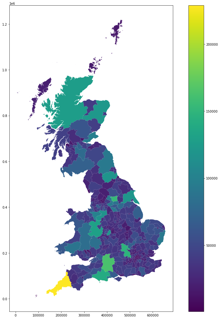
auth.plot('counts', figsize=(18, 18), legend=True)
<AxesSubplot:>
auth.to_parquet('../../urbangrammar_samba/local_authorities.pq')
/opt/conda/lib/python3.7/site-packages/ipykernel_launcher.py:1: UserWarning: this is an initial implementation of Parquet/Feather file support and associated metadata.  This is tracking version 0.1.0 of the metadata specification at https://github.com/geopandas/geo-arrow-spec

This metadata specification does not yet make stability promises.  We do not yet recommend using this in a production setting unless you are able to rewrite your Parquet/Feather files.

To further ignore this warning, you can do:
import warnings; warnings.filterwarnings('ignore', message='.*initial implementation of Parquet.*')
  """Entry point for launching an IPython kernel.
auth['counts'].describe()
count       368.000000
mean      38885.456522
std       26273.929125
min         484.000000
25%       23604.250000
50%       34107.500000
75%       43683.000000
max      228957.000000
Name: counts, dtype: float64
Geo-chunking Local Authority Districts
On this section we will create a partition of the UK that groups spatially contiguous local authorities (LADs) in regions that have similar number of buildings. For that, we will employ a regionalisation algorithm that instead of requiring the number of regions uses a floor threshold for the minimum number of building counts and tries to generate groups around that number (but above).
import pandas
import geopandas
import numpy as np
from mapclassify import greedy
from copy import deepcopy
from libpysal.weights import Queen, KNN, W
auth = geopandas.read_parquet("local_authorities.pq")
Note that we need to install region for this operation. The library is not part of gds_env:5.0 as it has been phased out in benefit of spopt, which will eventually be part of PySAL.
#! pip install region
import region
Data
We currently only have building counts for GB:
ax = auth.plot(color="k")
auth.loc[auth["counts"].isna(), :].plot(color="red", ax=ax)
<AxesSubplot:>
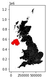
So, for now, we will remove Northern Ireland for this regionalisation:
auth = auth.dropna().reset_index()
Topology: W
To be able to build spatially constrained clusters, we need a way to capture topological relationships between local authorities. Spatial weights matrices come to the rescue here. Ideally, we need one that will give us contiguity relationships, but also that connects every observation. In a geography like ours, this must come from a combination of more than one criterium.
Our starting point is based on queen contiguity:
%time w_queen = Queen.from_dataframe(auth)
CPU times: user 1min 23s, sys: 2.7 s, total: 1min 26s
Wall time: 1min 25s
/opt/conda/lib/python3.7/site-packages/libpysal/weights/weights.py:172: UserWarning: The weights matrix is not fully connected:
 There are 7 disconnected components.
 There are 6 islands with ids: 43, 49, 319, 326, 328, 346.
  warnings.warn(message)
This produces a matrix with six islands -observations with no neighbors. To connect these to the rest of the graph, we are going to generate a nearest neighbor matrix, and use it for islands.
%time w_k1 = KNN.from_dataframe(auth, k=1)
CPU times: user 851 ms, sys: 4.04 ms, total: 855 ms
Wall time: 857 ms
/opt/conda/lib/python3.7/site-packages/libpysal/weights/weights.py:172: UserWarning: The weights matrix is not fully connected:
 There are 83 disconnected components.
  warnings.warn(message)
Our resulting matrix will be a queen contiguity one with islands connected to their nearest neighbor (and viceversa, for symmetry).
neighbors = deepcopy(w_queen.neighbors)
for i in w_queen.islands:
    j = w_k1.neighbors[i][0]
    neighbors[i] = [j]
    neighbors[j].append(i)
w = W(neighbors)
And we are ready to regionalise!
Regionalisation
The Max-P algorithms requires four hyper-parameters:
Topology: we’ll use
wNon-spatial features: to help the compactness of the regions, we will use the coordinates of each polygon’s centroid
A variable to guide the number of regions (
spatiall_extensive_attr): we will use the building count (counts) inauthwith a flipped signA floor
thresholdto ensure no region has at least that value of thespatiall_extensive_attr: following our estimates for Dask performance, we will use a maximum number of 200,000 (-200,000)
First, let’s pull out centroid coords:
cents = auth.geometry.centroid
xys = pandas.DataFrame({"X": cents.x,
                        "Y": cents.y
                       }, index=auth.index
                      )
And we can set up and run the optimisation. We are specifying that areas have a minimum of 100,000 buildings. By the nature of MaxP, it will try to create clusters roughly that amount, but the only guarantee is to be above the floor threshold. This is a relatively fast run:
%%time
from region.max_p_regions.heuristics import MaxPRegionsHeu
model = MaxPRegionsHeu(random_state=123445)
model.fit_from_w(w,
                 xys.values,
                 spatially_extensive_attr=auth["counts"].values,
                 threshold=100000
                )
CPU times: user 57.5 s, sys: 84.6 ms, total: 57.6 s
Wall time: 57.4 s
NOTE: I tried the following config which I interpret to impose two restrictions, a floor and a ceiling, but discarded it as the results are not significantly better and running time is considerably higher and the upper limit does not seem to apply.
%%time
from region.max_p_regions.heuristics import MaxPRegionsHeu
model = MaxPRegionsHeu(random_state=123445)
model.fit_from_w(w,
                 xys.values,
                 spatially_extensive_attr=auth[["counts"]].assign(neg_counts=-auth["counts"]).values,
                 threshold=np.array([150000, -200000])
                )
CPU times: user 57min 51s, sys: 841 ms, total: 57min 52s
Wall time: 57min 51s
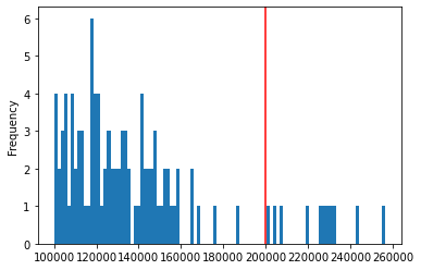
The resulting labels can be further explored:
sizes = auth.groupby(model.labels_)["counts"].sum()
print((f"There are {pandas.Series(model.labels_).unique().shape[0]} regions"\
       f" and {sizes[sizes>200000].shape[0]} are above 200,000 buildings"))
There are 103 regions and 11 are above 200,000 buildings
Number of LADs per region and the number of buildings they include:
g = auth.groupby(model.labels_)
region_stats = pandas.DataFrame({"n_lads": g.size(),
                                 "n_buildings": g["counts"].sum()
                                })
region_stats.describe().T
| count | mean | std | min | 25% | 50% | 75% | max | |
|---|---|---|---|---|---|---|---|---|
| n_lads | 103.0 | 3.572816 | 1.280333 | 1.0 | 3.0 | 3.0 | 4.0 | 12.0 |
| n_buildings | 103.0 | 138930.563107 | 35537.366693 | 100123.0 | 114334.5 | 128942.0 | 149196.0 | 256398.0 |
Distribution of number of buildings by region:
ax = region_stats["n_buildings"].plot.hist(bins=100)
ax.axvline(200000, color="red")
<matplotlib.lines.Line2D at 0x7f69bde704d0>
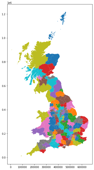
And the spatial layout of the regions:
auth.assign(lbls=model.labels_)\
    .plot(column="lbls",
          categorical=True,
          figsize=(12, 12)
         )
<AxesSubplot:>
Writing labels out
auth.assign(lbls=model.labels_)[["lad20cd", "lbls"]].to_csv("chunking_labels.csv")
Chunking data to parquet files
Now we use generated chunks to split building and enclosure data into chunked parquet files.
chunks = pandas.read_csv('../../urbangrammar_samba/spatial_signatures/local_auth_chunking_labels.csv', index_col=0)
auth = gpd.read_parquet('../../urbangrammar_samba/spatial_signatures/local_authorities.pq')
The first step is to dissolve each chunk to a single geometry.
districts = auth.merge(chunks, on='lad20cd', how='inner')
chunks = districts.dissolve('lbls')
chunks['chunkID'] = range(len(chunks))
chunks[['geometry', 'chunkID']].to_parquet('../../urbangrammar_samba/spatial_signatures/local_auth_chunks.pq')
/opt/conda/lib/python3.7/site-packages/ipykernel_launcher.py:1: UserWarning: this is an initial implementation of Parquet/Feather file support and associated metadata.  This is tracking version 0.1.0 of the metadata specification at https://github.com/geopandas/geo-arrow-spec

This metadata specification does not yet make stability promises.  We do not yet recommend using this in a production setting unless you are able to rewrite your Parquet/Feather files.

To further ignore this warning, you can do:
import warnings; warnings.filterwarnings('ignore', message='.*initial implementation of Parquet.*')
  """Entry point for launching an IPython kernel.
df['uID'] = range(len(df))
Above, we have also assigned unique IDs to both chunks and to buildings, below we do the same for enclosuers. This allows easy attribute-based merging of data in the future instead of costly spatial joins.
enclosures = gpd.read_parquet('../../urbangrammar_samba/spatial_signatures/enclosures.pq')
enclosures['enclosureID'] = range(len(enclosures))
We first use spatial index to chunk enclosures as our top-level geometry and chunk buildings based on enclosures. That ensures that both layr align on the edges of district chunks. The resulting chunked GeoDataFrames are then saved to parquet files.
inp, res = enclosures.centroid.sindex.query_bulk(chunks.geometry, predicate='intersects')
blg_six = df.centroid.sindex
from tqdm.notebook import tqdm

for chunk_id in tqdm(range(len(chunks)), total=len(chunks)):
    wihtin_chunk = enclosures.iloc[res[inp == chunk_id]]
    wihtin_chunk.to_parquet(f'../../urbangrammar_samba/spatial_signatures/enclosures/encl_{chunk_id}.pq')

    i, r = blg_six.query_bulk(wihtin_chunk.geometry, predicate='intersects')
    df.iloc[np.unique(r)][['uID', 'geometry']].to_parquet(f'../../urbangrammar_samba/spatial_signatures/buildings/blg_{chunk_id}.pq')
/opt/conda/lib/python3.7/site-packages/ipykernel_launcher.py:5: UserWarning: this is an initial implementation of Parquet/Feather file support and associated metadata.  This is tracking version 0.1.0 of the metadata specification at https://github.com/geopandas/geo-arrow-spec

This metadata specification does not yet make stability promises.  We do not yet recommend using this in a production setting unless you are able to rewrite your Parquet/Feather files.

To further ignore this warning, you can do:
import warnings; warnings.filterwarnings('ignore', message='.*initial implementation of Parquet.*')
  """
/opt/conda/lib/python3.7/site-packages/ipykernel_launcher.py:8: UserWarning: this is an initial implementation of Parquet/Feather file support and associated metadata.  This is tracking version 0.1.0 of the metadata specification at https://github.com/geopandas/geo-arrow-spec

This metadata specification does not yet make stability promises.  We do not yet recommend using this in a production setting unless you are able to rewrite your Parquet/Feather files.

To further ignore this warning, you can do:
import warnings; warnings.filterwarnings('ignore', message='.*initial implementation of Parquet.*')