Fetch Ordnance Survey (Open) Data
Dowload files from OS OpenData API, save zip, open it in GeoPandas and dump to a PostGIS database.
Process OS MasterMap Building height data
To establish a connection to the database, this notebook is using docker environment variables. Start docker as docker run -it -e DB_PORT=<port> -e DB_USER=<username> -e DB_PWD=<password> -e DB_HOST=<host> darribas/gds_dev:5.0.
import os
import zipfile
import requests

import fiona
import geopandas as gpd

from sqlalchemy import create_engine
OpenRoads
Download from API
Request the list of products available using Ordnance Survey API and filter 'OpenRoads' record.
response = requests.get('https://api.os.uk/downloads/v1/products')
json = response.json()
for product in json:
    if product['id'] == 'OpenRoads':
        url = product['url']
roads = requests.get(url)
roads_json = roads.json()
roads_json
{'id': 'OpenRoads',
 'name': 'OS Open Roads',
 'description': 'Get a high-level view of the road network, from motorways to country lanes.',
 'version': '2020-04',
 'documentationUrl': 'https://www.ordnancesurvey.co.uk/business-government/products/open-map-roads',
 'dataStructures': ['Vector'],
 'category': 'Networks',
 'formats': [{'format': 'ESRI® Shapefile'},
  {'format': 'GML', 'subformat': '3'},
  {'format': 'GeoPackage'}],
 'url': 'https://api.os.uk/downloads/v1/products/OpenRoads',
 'imageCount': 3,
 'imageTemplate': 'https://api.os.uk/downloads/v1/products/OpenRoads/images/{index}',
 'downloadsUrl': 'https://api.os.uk/downloads/v1/products/OpenRoads/downloads',
 'areas': ['GB']}
Get download URLs.
download = requests.get(roads_json['downloadsUrl'])
download_json = download.json()
download_json
[{'md5': '60286049CB76C9D6364F0FE87090202C',
  'size': 541236838,
  'url': 'https://api.os.uk/downloads/v1/products/OpenRoads/downloads?area=GB&format=ESRI%C2%AE+Shapefile&redirect',
  'format': 'ESRI® Shapefile',
  'area': 'GB',
  'fileName': 'oproad_essh_gb.zip'},
 {'md5': '84E66CAFCEA9DD695A68540DE9379D4C',
  'size': 542188036,
  'url': 'https://api.os.uk/downloads/v1/products/OpenRoads/downloads?area=GB&format=GML&subformat=3&redirect',
  'format': 'GML',
  'subformat': '3',
  'area': 'GB',
  'fileName': 'oproad_gml3_gb.zip'},
 {'md5': 'E1FC93742CAAE7EF70C675749077AB42',
  'size': 931331115,
  'url': 'https://api.os.uk/downloads/v1/products/OpenRoads/downloads?area=GB&format=GeoPackage&redirect',
  'format': 'GeoPackage',
  'area': 'GB',
  'fileName': 'oproad_gpkg_gb.zip'}]
Save zipped GeoPackage to disk. Since we do not know its contents, we can’t read it directly to GeoPandas.
for fileformat in download_json:
    if fileformat['format'] == 'GeoPackage':
        with open(fileformat['fileName'], "wb") as down:
            down.write(requests.get(fileformat['url']).content)
            down.close()
Explore the contents of the downloaded file.
gpkg = zipfile.ZipFile(fileformat['fileName'])
gpkg.namelist()
['readme.txt', 'data/oproad_gb.gpkg', 'doc/licence.txt']
Read GeoPackage to GeoPandas.
gdf = gpd.read_file('zip://' + fileformat['fileName'] + '!' + gpkg.namelist()[1])
gdf.head()
| id | endNode | startNode | roadNumberTOID | roadNameTOID | fictitious | roadClassification | roadFunction | formOfWay | length | ... | loop | primaryRoute | trunkRoad | roadClassificationNumber | name1 | name1_lang | name2 | name2_lang | roadStructure | geometry | |
|---|---|---|---|---|---|---|---|---|---|---|---|---|---|---|---|---|---|---|---|---|---|
| 0 | id04AE862E-2A92-41BC-BBE0-6AF05DDDE57E | idD6A4C11F-3E69-4E22-9711-2DE393FCF0A2 | idF4241DAB-6DC5-4C0E-90FA-161BF2270663 | None | None | False | Unknown | Minor Road | Single Carriageway | 500 | ... | False | False | False | None | None | None | None | None | None | LINESTRING (463181.000 1212313.000, 463361.630... |
| 1 | idDF59D6BB-3E5C-4BFA-91E9-81FAFB70D79C | idE7211001-42DF-416C-9304-D39F9F66D4A6 | id8F2F6CFE-2E3D-4CA3-AD41-124E098F7197 | None | None | False | Unknown | Minor Road | Single Carriageway | 525 | ... | False | False | False | None | None | None | None | None | None | LINESTRING (464759.470 1212349.740, 464729.000... |
| 2 | id92D440D3-B707-45F8-8173-E7EE22663573 | idCB2E6127-8894-4372-8B1A-D8EECC2B6F8C | id9404ED22-2647-483C-81B6-C294CF3B8712 | None | None | False | Unknown | Minor Road | Single Carriageway | 338 | ... | False | False | False | None | None | None | None | None | None | LINESTRING (463644.000 1212504.000, 463805.030... |
| 3 | id7AA3E18E-21A4-4FD4-B308-EA0B3EA67046 | id1CC69224-6F4C-4706-A658-2175240DE21A | id63BA7519-6915-4553-BEA5-AF9C57EF73A5 | None | None | False | Unknown | Restricted Local Access Road | Single Carriageway | 99 | ... | False | False | False | None | None | None | None | None | None | LINESTRING (464193.000 1212455.000, 464217.080... |
| 4 | idB9590DD5-48C1-47F6-9B1A-044C454CCB00 | id63BA7519-6915-4553-BEA5-AF9C57EF73A5 | idE7211001-42DF-416C-9304-D39F9F66D4A6 | None | osgb4000000003210673 | False | Unknown | Minor Road | Single Carriageway | 104 | ... | False | False | False | None | Beach Road | None | None | None | None | LINESTRING (464287.780 1212496.830, 464240.390... |
5 rows × 21 columns
Save GeoDataFrame to PostGIS
user = os.environ.get('DB_USER')
pwd = os.environ.get('DB_PWD')
host = os.environ.get('DB_HOST')
port = os.environ.get('DB_PORT')
db_connection_url = f"postgres+psycopg2://{user}:{pwd}@{host}:{port}/built_env"
engine = create_engine(db_connection_url)
gdf.to_postgis("openroads_200803", engine, if_exists='replace')
OpenMap - Local (building layer + barriers)
Download from API
Now we get url of OpenMap - Local product, from which we extract buidling footprints and layers forming morphological barriers.
for product in json:
    if product['id'] == 'OpenMapLocal':
        url = product['url']
        print(url)
https://api.os.uk/downloads/v1/products/OpenMapLocal
Unlike above, OpenMap comes in split into tiles. We want the whole GB, so we have to specify it as area.
openmap = requests.get(url)
openmap_json = openmap.json()

download = requests.get(openmap_json['downloadsUrl'])
download_json = download.json()

for tile in download_json:
    if tile['area'] == 'GB' and tile['format'] == 'GML':
        url = tile['url']
        filename = tile['fileName']
        print(tile)
{'md5': '8D26A678FC6C0990633427519FF6F55D', 'size': 2239775851, 'url': 'https://api.os.uk/downloads/v1/products/OpenMapLocal/downloads?area=GB&format=GML&subformat=3&redirect', 'format': 'GML', 'subformat': '3', 'area': 'GB', 'fileName': 'opmplc_gml3_gb.zip'}
with open(filename, "wb") as down:
    down.write(requests.get(url).content)
    down.close()
Save files to PostGIS
Because downloaded zip still containes data split into tiles, we will have to iterate over them and append them individually to the same table.
gml = zipfile.ZipFile(filename)
gml.namelist()
['/data/',
 '/doc/',
 '/doc/licence.txt',
 '/readme.txt',
 'data/HP/HP.gml',
 'data/HT/HT.gml',
 'data/HU/HU.gml',
 'data/HW/HW.gml',
 'data/HX/HX.gml',
 'data/HY/HY.gml',
 'data/HZ/HZ.gml',
 'data/NA/NA.gml',
 'data/NB/NB.gml',
 'data/NC/NC.gml',
 'data/ND/ND.gml',
 'data/NF/NF.gml',
 'data/NG/NG.gml',
 'data/NH/NH.gml',
 'data/NJ/NJ.gml',
 'data/NK/NK.gml',
 'data/NL/NL.gml',
 'data/NM/NM.gml',
 'data/NN/NN.gml',
 'data/NO/NO.gml',
 'data/NR/NR.gml',
 'data/NS/NS.gml',
 'data/NT/NT.gml',
 'data/NU/NU.gml',
 'data/NW/NW.gml',
 'data/NX/NX.gml',
 'data/NY/NY.gml',
 'data/NZ/NZ.gml',
 'data/OV/OV.gml',
 'data/SD/SD.gml',
 'data/SE/SE.gml',
 'data/SH/SH.gml',
 'data/SJ/SJ.gml',
 'data/SK/SK.gml',
 'data/SM/SM.gml',
 'data/SN/SN.gml',
 'data/SO/SO.gml',
 'data/SP/SP.gml',
 'data/SR/SR.gml',
 'data/SS/SS.gml',
 'data/ST/ST.gml',
 'data/SU/SU.gml',
 'data/SV/SV.gml',
 'data/SW/SW.gml',
 'data/SX/SX.gml',
 'data/SY/SY.gml',
 'data/SZ/SZ.gml',
 'data/TA/TA.gml',
 'data/TF/TF.gml',
 'data/TG/TG.gml',
 'data/TL/TL.gml',
 'data/TM/TM.gml',
 'data/TQ/TQ.gml',
 'data/TR/TR.gml',
 'data/TV/TV.gml']
Since gml files come with more layers that we are looking for, let’s explore them and pick only those of interest.
fiona.listlayers('zip://' + filename + '!' + gml.namelist()[-1])
['Building',
 'CarChargingPoint',
 'Foreshore',
 'FunctionalSite',
 'ImportantBuilding',
 'NamedPlace',
 'RailwayStation',
 'RailwayTrack',
 'Road',
 'Roundabout',
 'SurfaceWater_Area',
 'SurfaceWater_Line',
 'TidalBoundary',
 'TidalWater',
 'Woodland']
Finally, we can iterate over the contents of downloaded zip and store relevant data in our PostGIS table. Note the if_exists='append option, which ensures that we do not overwrite one tile with another. There are tiles covering only sea - those do not have wanted (e.g. Building) layer.
Buildings
for file in gml.namelist():
    if file.startswith('data/'):
        if 'Building' in fiona.listlayers('zip://' + filename + '!' + file):
            gdf = gpd.read_file('zip://' + filename + '!' + file, layer='Building')
            gdf.to_postgis("openmap_buildings_200814", engine, if_exists='append')
        else:
            print(file, 'does not contain Building layer.')
data/OV/OV.gml does not contain Building layer.
Railway
for file in gml.namelist():
    if file.startswith('data/'):
        if 'RailwayTrack' in fiona.listlayers('zip://' + filename + '!' + file):
            gdf = gpd.read_file('zip://' + filename + '!' + file, layer='RailwayTrack')
            gdf.to_postgis("openmap_railwaytrack_200824", engine, if_exists='append')
        else:
            print(file, 'does not contain Railway layer.')
data/HP/HP.gml does not contain Railway layer.
data/HT/HT.gml does not contain Railway layer.
data/HW/HW.gml does not contain Railway layer.
data/HX/HX.gml does not contain Railway layer.
data/HY/HY.gml does not contain Railway layer.
data/HZ/HZ.gml does not contain Railway layer.
data/NA/NA.gml does not contain Railway layer.
data/NB/NB.gml does not contain Railway layer.
data/NF/NF.gml does not contain Railway layer.
data/NL/NL.gml does not contain Railway layer.
data/NR/NR.gml does not contain Railway layer.
data/NW/NW.gml does not contain Railway layer.
data/OV/OV.gml does not contain Railway layer.
data/SR/SR.gml does not contain Railway layer.
data/SV/SV.gml does not contain Railway layer.
Surface Water
for file in gml.namelist():
    if file.startswith('data/'):
        if 'SurfaceWater_Area' in fiona.listlayers('zip://' + filename + '!' + file):
            gdf = gpd.read_file('zip://' + filename + '!' + file, layer='SurfaceWater_Area')
            gdf.to_postgis("openmap_surfacewater_area_200824", engine, if_exists='append')
        else:
            print(file, 'does not contain SurfaceWater_Area layer.')
        if 'SurfaceWater_Line' in fiona.listlayers('zip://' + filename + '!' + file):
            gdf = gpd.read_file('zip://' + filename + '!' + file, layer='SurfaceWater_Line')
            gdf.to_postgis("openmap_surfacewater_line_200824", engine, if_exists='append')
        else:
            print(file, 'does not contain SurfaceWater_Line layer.')
data/HW/HW.gml does not contain SurfaceWater_Line layer.
data/HX/HX.gml does not contain SurfaceWater_Area layer.
data/HX/HX.gml does not contain SurfaceWater_Line layer.
data/OV/OV.gml does not contain SurfaceWater_Area layer.
data/OV/OV.gml does not contain SurfaceWater_Line layer.
Woodland
for file in gml.namelist():
    if file.startswith('data/'):
        if 'Woodland' in fiona.listlayers('zip://' + filename + '!' + file):
            gdf = gpd.read_file('zip://' + filename + '!' + file, layer='Woodland')
            gdf.to_postgis("openmap_woodland_200824", engine, if_exists='append')
        else:
            print(file, 'does not contain Woodland layer.')
data/HT/HT.gml does not contain Woodland layer.
data/HW/HW.gml does not contain Woodland layer.
data/HX/HX.gml does not contain Woodland layer.
data/HZ/HZ.gml does not contain Woodland layer.
data/NA/NA.gml does not contain Woodland layer.
data/OV/OV.gml does not contain Woodland layer.
Tidal water
for file in gml.namelist():
    if file.startswith('data/'):
        if 'TidalWater' in fiona.listlayers('zip://' + filename + '!' + file):
            gdf = gpd.read_file('zip://' + filename + '!' + file, layer='TidalWater')
            gdf.to_postgis("openmap_tidalwater_200908", engine, if_exists='append')
        else:
            print(file, 'does not contain TidalWater layer.')
Tidal Boundary
Showing high water mark (coinciding with tidal water boundary) and low water mark.
for file in gml.namelist():
    if file.startswith('data/'):
        if 'TidalBoundary' in fiona.listlayers('zip://' + filename + '!' + file):
            gdf = gpd.read_file('zip://' + filename + '!' + file, layer='TidalBoundary')
            gdf.to_postgis("openmap_tidalboundary_200908", engine, if_exists='append')
        else:
            print(file, 'does not contain TidalBoundary layer.')
data/SP/SP.gml does not contain TidalBoundary layer.
OpenRivers
for product in json:
    if product['id'] == 'OpenRivers':
        url = product['url']
rivers = requests.get(url)
rivers_json = rivers.json()
rivers_json
{'id': 'OpenRivers',
 'name': 'OS Open Rivers',
 'description': 'Understand how watercourses in Great Britain join up.',
 'version': '2020-04',
 'documentationUrl': 'https://www.ordnancesurvey.co.uk/business-government/products/open-map-rivers',
 'dataStructures': ['Vector'],
 'category': 'Networks',
 'formats': [{'format': 'ESRI® Shapefile'},
  {'format': 'GML', 'subformat': '3'},
  {'format': 'GeoPackage'}],
 'url': 'https://api.os.uk/downloads/v1/products/OpenRivers',
 'areas': ['GB'],
 'imageCount': 3,
 'imageTemplate': 'https://api.os.uk/downloads/v1/products/OpenRivers/images/{index}',
 'downloadsUrl': 'https://api.os.uk/downloads/v1/products/OpenRivers/downloads'}
download = requests.get(rivers_json['downloadsUrl'])
download_json = download.json()
download_json
[{'md5': '80479F3A41EF2DB802F4B1D45C8FECF1',
  'size': 38392248,
  'url': 'https://api.os.uk/downloads/v1/products/OpenRivers/downloads?area=GB&format=ESRI%C2%AE+Shapefile&redirect',
  'format': 'ESRI® Shapefile',
  'area': 'GB',
  'fileName': 'oprvrs_essh_gb.zip'},
 {'md5': 'A5E9FA79510B4B30D1FFC0F00A76B2EB',
  'size': 39484486,
  'url': 'https://api.os.uk/downloads/v1/products/OpenRivers/downloads?area=GB&format=GML&subformat=3&redirect',
  'format': 'GML',
  'subformat': '3',
  'area': 'GB',
  'fileName': 'oprvrs_gml3_gb.zip'},
 {'md5': '62157F02DA12C1C134FD003B030E61F7',
  'size': 53972360,
  'url': 'https://api.os.uk/downloads/v1/products/OpenRivers/downloads?area=GB&format=GeoPackage&redirect',
  'format': 'GeoPackage',
  'area': 'GB',
  'fileName': 'oprvrs_gpkg_gb.zip'}]
for fileformat in download_json:
    if fileformat['format'] == 'GeoPackage':
        with open(fileformat['fileName'], "wb") as down:
            down.write(requests.get(fileformat['url']).content)
            down.close()
gpkg = zipfile.ZipFile(fileformat['fileName'])
gpkg.namelist()
['readme.txt', 'data/oprvrs_gb.gpkg', 'doc/licence.txt']
fiona.listlayers('zip://' + fileformat['fileName'] + '!' + gpkg.namelist()[1])
['HydroNode', 'WatercourseLink']
gdf = gpd.read_file('zip://' + fileformat['fileName'] + '!' + gpkg.namelist()[1], layer='WatercourseLink')
gdf.to_postgis("openrivers_200909", engine, if_exists='replace')
Save samples of OS MasterMap Building height layer to parquet files
Processing raw downloads of OS MasterMap Building height layer from digimap.edina.ac.uk to a single parquet file per city. Initial downloaded zip files have been extracted and renamed to indicate the location. The contents of each folder is unchanged.
The structure of current directory:
notebook.ipynb
glasgow/*
leeds/*
edinburgh/*
manchester/*
liverpool/*
where * is the original content of downloaded zip file.
First we get the list of cities based on folders:
cities = [city for city in glob.glob('**') if not city.endswith('ipynb')]
The data are stored in tiled gdb files which needs to be merged together first. We loop through cities and concatenate all gdb files in each into a single GeoDataFrame, which is then saved to a single parquet file.
for city in cities:
    files = glob.glob(f'{city}/**/**/**')
    merged = pd.concat([gpd.read_file(file) for file in files if file.endswith('gdb')])
    merged.to_parquet(f'{city}.pq')
Coastline
To get the external boundary of the GB, we will also need coastline geometry. That is downloadable from data.gov.uk.
coastline = gpd.read_file('http://geoportal1-ons.opendata.arcgis.com/datasets/f2c2211ff185418484566b2b7a5e1300_1.zip?outSR={%22latestWkid%22:27700,%22wkid%22:27700}')
coastline
| objectid | ctry17cd | ctry17nm | ctry17nmw | bng_e | bng_n | long | lat | st_areasha | st_lengths | geometry | |
|---|---|---|---|---|---|---|---|---|---|---|---|
| 0 | 1 | E92000001 | England | Lloegr | 394881 | 370341 | -2.07813 | 53.230099 | 1.329461e+11 | 4.776071e+06 | MULTIPOLYGON (((398210.896 657405.599, 398214.... |
| 1 | 2 | S92000003 | Scotland | Yr Alban | 277746 | 700060 | -3.97091 | 56.177429 | 8.022646e+10 | 1.790847e+07 | MULTIPOLYGON (((320228.803 976907.502, 320230.... |
| 2 | 3 | W92000004 | Wales | Cymru | 263406 | 242881 | -3.99416 | 52.067410 | 2.122477e+10 | 2.027624e+06 | MULTIPOLYGON (((312661.601 385723.097, 312730.... |
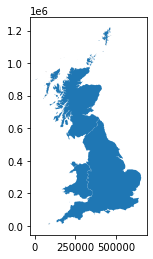
coastline.plot()
<AxesSubplot:>
coastline.to_postgis("gb_countries_2017", engine, if_exists='replace')
However, that proved to be unprecise. Coastline layer from Strategi product (although deprecated now) is better for our purpose.
json = response.json()
for product in json:
    if product['id'] == 'Strategi':
        url = product['url']
strategi = requests.get(url)
strategi_json = strategi.json()
strategi_json
{'id': 'Strategi',
 'name': 'Strategi®',
 'description': 'A regional vector map dataset, railways, airports, rivers, villages, woods, land use and place names.',
 'version': '2016-01',
 'documentationUrl': 'https://www.ordnancesurvey.co.uk/business-government/products/strategi',
 'dataStructures': ['Vector'],
 'category': 'Mapping',
 'formats': [{'format': 'DXF'},
  {'format': 'ESRI® Shapefile'},
  {'format': 'MapInfo® TAB'}],
 'warning': "(Note: Strategi won't be updated again. We released our final update in January 2016.)",
 'url': 'https://api.os.uk/downloads/v1/products/Strategi',
 'imageCount': 3,
 'imageTemplate': 'https://api.os.uk/downloads/v1/products/Strategi/images/{index}',
 'downloadsUrl': 'https://api.os.uk/downloads/v1/products/Strategi/downloads',
 'areas': ['GB']}
download = requests.get(strategi_json['downloadsUrl'])
download_json = download.json()
download_json
[{'md5': 'AE5655AD0F52B777AF53462552222CE4',
  'size': 58134716,
  'url': 'https://api.os.uk/downloads/v1/products/Strategi/downloads?area=GB&format=DXF&redirect',
  'format': 'DXF',
  'area': 'GB',
  'fileName': 'strtgi_dxf_gb.zip'},
 {'md5': '374550DB97DDC152554F97DBA2421E80',
  'size': 40443471,
  'url': 'https://api.os.uk/downloads/v1/products/Strategi/downloads?area=GB&format=ESRI%C2%AE+Shapefile&redirect',
  'format': 'ESRI® Shapefile',
  'area': 'GB',
  'fileName': 'strtgi_essh_gb.zip'},
 {'md5': '7550A30048FABDA32FAF16D8217A2687',
  'size': 55439034,
  'url': 'https://api.os.uk/downloads/v1/products/Strategi/downloads?area=GB&format=MapInfo%C2%AE+TAB&redirect',
  'format': 'MapInfo® TAB',
  'area': 'GB',
  'fileName': 'strtgi_mapt_gb.zip'}]
for fileformat in download_json:
    if fileformat['format'] == 'ESRI® Shapefile':
        with open(fileformat['fileName'], "wb") as down:
            down.write(requests.get(fileformat['url']).content)
            down.close()
gml = zipfile.ZipFile('strtgi_essh_gb.zip')
gml.namelist()
['strtgi_essh_gb/',
 'strtgi_essh_gb/data/',
 'strtgi_essh_gb/data/admin_line.dbf',
 'strtgi_essh_gb/data/admin_line.prj',
 'strtgi_essh_gb/data/admin_line.shp',
 'strtgi_essh_gb/data/admin_line.shx',
 'strtgi_essh_gb/data/admin_seed.dbf',
 'strtgi_essh_gb/data/admin_seed.prj',
 'strtgi_essh_gb/data/admin_seed.shp',
 'strtgi_essh_gb/data/admin_seed.shx',
 'strtgi_essh_gb/data/antiquity_line.dbf',
 'strtgi_essh_gb/data/antiquity_line.prj',
 'strtgi_essh_gb/data/antiquity_line.shp',
 'strtgi_essh_gb/data/antiquity_line.shx',
 'strtgi_essh_gb/data/a_road.dbf',
 'strtgi_essh_gb/data/a_road.prj',
 'strtgi_essh_gb/data/a_road.shp',
 'strtgi_essh_gb/data/a_road.shx',
 'strtgi_essh_gb/data/b_road.dbf',
 'strtgi_essh_gb/data/b_road.prj',
 'strtgi_essh_gb/data/b_road.shp',
 'strtgi_essh_gb/data/b_road.shx',
 'strtgi_essh_gb/data/coastline.dbf',
 'strtgi_essh_gb/data/coastline.prj',
 'strtgi_essh_gb/data/coastline.shp',
 'strtgi_essh_gb/data/coastline.shx',
 'strtgi_essh_gb/data/ferry_box.dbf',
 'strtgi_essh_gb/data/ferry_box.prj',
 'strtgi_essh_gb/data/ferry_box.shp',
 'strtgi_essh_gb/data/ferry_box.shx',
 'strtgi_essh_gb/data/ferry_line.dbf',
 'strtgi_essh_gb/data/ferry_line.prj',
 'strtgi_essh_gb/data/ferry_line.shp',
 'strtgi_essh_gb/data/ferry_line.shx',
 'strtgi_essh_gb/data/foreshor_region.dbf',
 'strtgi_essh_gb/data/foreshor_region.prj',
 'strtgi_essh_gb/data/foreshor_region.shp',
 'strtgi_essh_gb/data/foreshor_region.shx',
 'strtgi_essh_gb/data/general_text/',
 'strtgi_essh_gb/data/general_text/bnd.adf',
 'strtgi_essh_gb/data/general_text/lab.adf',
 'strtgi_essh_gb/data/general_text/text.tat',
 'strtgi_essh_gb/data/general_text/text.txt',
 'strtgi_essh_gb/data/general_text/text.txx',
 'strtgi_essh_gb/data/general_text/tic.adf',
 'strtgi_essh_gb/data/general_text/tol.adf',
 'strtgi_essh_gb/data/general_text.dbf',
 'strtgi_essh_gb/data/general_text.prj',
 'strtgi_essh_gb/data/general_text.shp',
 'strtgi_essh_gb/data/general_text.shx',
 'strtgi_essh_gb/data/gridlines.dbf',
 'strtgi_essh_gb/data/gridlines.prj',
 'strtgi_essh_gb/data/gridlines.shp',
 'strtgi_essh_gb/data/gridlines.shx',
 'strtgi_essh_gb/data/info/',
 'strtgi_essh_gb/data/info/arc.dir',
 'strtgi_essh_gb/data/info/arc0000.dat',
 'strtgi_essh_gb/data/info/arc0000.nit',
 'strtgi_essh_gb/data/info/arc0001.dat',
 'strtgi_essh_gb/data/info/arc0001.nit',
 'strtgi_essh_gb/data/info/arc0002.dat',
 'strtgi_essh_gb/data/info/arc0002.nit',
 'strtgi_essh_gb/data/info/arc0003.dat',
 'strtgi_essh_gb/data/info/arc0003.nit',
 'strtgi_essh_gb/data/info/arc0004.dat',
 'strtgi_essh_gb/data/info/arc0004.nit',
 'strtgi_essh_gb/data/info/arc0005.dat',
 'strtgi_essh_gb/data/info/arc0005.nit',
 'strtgi_essh_gb/data/lakes_region.dbf',
 'strtgi_essh_gb/data/lakes_region.prj',
 'strtgi_essh_gb/data/lakes_region.shp',
 'strtgi_essh_gb/data/lakes_region.shx',
 'strtgi_essh_gb/data/land_use_seed.dbf',
 'strtgi_essh_gb/data/land_use_seed.prj',
 'strtgi_essh_gb/data/land_use_seed.shp',
 'strtgi_essh_gb/data/land_use_seed.shx',
 'strtgi_essh_gb/data/land_use_symbol.dbf',
 'strtgi_essh_gb/data/land_use_symbol.prj',
 'strtgi_essh_gb/data/land_use_symbol.shp',
 'strtgi_essh_gb/data/land_use_symbol.shx',
 'strtgi_essh_gb/data/minor_road.dbf',
 'strtgi_essh_gb/data/minor_road.prj',
 'strtgi_essh_gb/data/minor_road.shp',
 'strtgi_essh_gb/data/minor_road.shx',
 'strtgi_essh_gb/data/motorway.dbf',
 'strtgi_essh_gb/data/motorway.prj',
 'strtgi_essh_gb/data/motorway.shp',
 'strtgi_essh_gb/data/motorway.shx',
 'strtgi_essh_gb/data/national_park.dbf',
 'strtgi_essh_gb/data/national_park.prj',
 'strtgi_essh_gb/data/national_park.shp',
 'strtgi_essh_gb/data/national_park.shx',
 'strtgi_essh_gb/data/primary_road.dbf',
 'strtgi_essh_gb/data/primary_road.prj',
 'strtgi_essh_gb/data/primary_road.shp',
 'strtgi_essh_gb/data/primary_road.shx',
 'strtgi_essh_gb/data/railway_line.dbf',
 'strtgi_essh_gb/data/railway_line.prj',
 'strtgi_essh_gb/data/railway_line.shp',
 'strtgi_essh_gb/data/railway_line.shx',
 'strtgi_essh_gb/data/railway_point.dbf',
 'strtgi_essh_gb/data/railway_point.prj',
 'strtgi_essh_gb/data/railway_point.shp',
 'strtgi_essh_gb/data/railway_point.shx',
 'strtgi_essh_gb/data/rivers_line.dbf',
 'strtgi_essh_gb/data/rivers_line.prj',
 'strtgi_essh_gb/data/rivers_line.shp',
 'strtgi_essh_gb/data/rivers_line.shx',
 'strtgi_essh_gb/data/road_point.dbf',
 'strtgi_essh_gb/data/road_point.prj',
 'strtgi_essh_gb/data/road_point.shp',
 'strtgi_essh_gb/data/road_point.shx',
 'strtgi_essh_gb/data/settlement_seed.dbf',
 'strtgi_essh_gb/data/settlement_seed.prj',
 'strtgi_essh_gb/data/settlement_seed.shp',
 'strtgi_essh_gb/data/settlement_seed.shx',
 'strtgi_essh_gb/data/spot_height.dbf',
 'strtgi_essh_gb/data/spot_height.prj',
 'strtgi_essh_gb/data/spot_height.shp',
 'strtgi_essh_gb/data/spot_height.shx',
 'strtgi_essh_gb/data/Strategi.lyr',
 'strtgi_essh_gb/data/tourist_symbol.dbf',
 'strtgi_essh_gb/data/tourist_symbol.prj',
 'strtgi_essh_gb/data/tourist_symbol.shp',
 'strtgi_essh_gb/data/tourist_symbol.shx',
 'strtgi_essh_gb/data/transport_symbol.dbf',
 'strtgi_essh_gb/data/transport_symbol.prj',
 'strtgi_essh_gb/data/transport_symbol.shp',
 'strtgi_essh_gb/data/transport_symbol.shx',
 'strtgi_essh_gb/data/transport_text.dbf',
 'strtgi_essh_gb/data/transport_text.prj',
 'strtgi_essh_gb/data/transport_text.shp',
 'strtgi_essh_gb/data/transport_text.shx',
 'strtgi_essh_gb/data/transport_txt/',
 'strtgi_essh_gb/data/transport_txt/bnd.adf',
 'strtgi_essh_gb/data/transport_txt/lab.adf',
 'strtgi_essh_gb/data/transport_txt/text.tat',
 'strtgi_essh_gb/data/transport_txt/text.txt',
 'strtgi_essh_gb/data/transport_txt/text.txx',
 'strtgi_essh_gb/data/transport_txt/tic.adf',
 'strtgi_essh_gb/data/transport_txt/tol.adf',
 'strtgi_essh_gb/data/urban_region.dbf',
 'strtgi_essh_gb/data/urban_region.prj',
 'strtgi_essh_gb/data/urban_region.shp',
 'strtgi_essh_gb/data/urban_region.shx',
 'strtgi_essh_gb/data/woodland_region.dbf',
 'strtgi_essh_gb/data/woodland_region.prj',
 'strtgi_essh_gb/data/woodland_region.shp',
 'strtgi_essh_gb/data/woodland_region.shx',
 'strtgi_essh_gb/doc/',
 'strtgi_essh_gb/doc/licence.txt',
 'strtgi_essh_gb/doc/StrategiSymbols.ttf',
 'strtgi_essh_gb/doc/Strategi_Area.txt',
 'strtgi_essh_gb/doc/Strategi_Release_2016_Change.txt',
 'strtgi_essh_gb/gazetteer/',
 'strtgi_essh_gb/gazetteer/Strategi_Gazetteer_2016.txt',
 'strtgi_essh_gb/Strategi_Readme.txt',
 'strtgi_essh_gb/doc/Styling_Guide.pdf']
coastline = gpd.read_file('zip://strtgi_essh_gb.zip!strtgi_essh_gb/data/coastline.shp')
coastline.to_postgis("gb_coastline_2016", engine, if_exists='replace')